Patents Provide Look at Past and Future of AI in Geological Surveying
Artificial intelligence (AI) tools have been used in geological survey methods for many years. Gaining insight into the scale and trends of this implementation could assist surveyors in making informed decisions about buying or developing new technologies.
Source: sesame/Getty Images
This research conducts a statistical analysis of patent activity data. The introduction provides short notions on specifics of patent research, fields of research, and methodology. The main section provides an overview of the general statistics, distribution, dynamics diagrams, the share of inventions with AI in the main geological survey categories, an analysis of growth, growth rate, and some possible conclusions for users and technology developers.
Specifics of Patent Research Research on patent activity relies on official publications from patent offices, such as granted patents and patent applications, which provide highly valuable information. Patent documentation has the following main advantages:
Practical relevance—Unlike theoretical or hypothetical solutions, patent documentation focuses on inventions that are valuable for practical exploitation. This emphasis on practicality ensures that the obtained information is directly applicable to real-world scenarios.
Timeliness—Patent applications typically are published approximately 18 months after filing, which means the information becomes available before the products or technologies are introduced in the market. This up-to-date nature of patent information allows researchers to stay ahead of developments.
Comprehensive insight—Patent documents not only provide detailed information about the technology itself but also disclose crucial data on who filed the patent and when. This additional information enhances the understanding of the technology landscape and facilitates further analysis.
Thus, patent information unveils very valuable insights into ongoing projects and emerging technologies within a specific field. While several commercial services offer access to patent publication databases for research purposes, there are also powerful free services, including Patentscope from the World Intellectual Property Organization, Espacenet from the European Patent Office, and Google Patents.
The presented research uses the Google Patents database. The total accessible number of patent documents in the Google Patents database exceeds 19 million official publications from 105 countries.
Field of Research and Methodology This study focuses on retrieving and analyzing patent activity for technologies utilizing AI within six main categories of geological surveying and covers the period from 1 January 1980 to 1 May 2023. The research starting point coincides with the time when there were core scientific publications discussing the potential use of AI tools for practical computations.
The study’s geological surveying categories are the following:
Seismic and acoustic
Magnetic, electrical, electromagnetic, and nuclear magnetic resonance spectroscopy (NMR)
Nuclear radiation, including gamma ray
Optical
Gravitational
Combination of methods and geomodelling, not related to particular measurements
The search queries have the following general structure where the first part is constant and aims to get results in the main field of using AI in geological surveying and the second part aims to filter results for specific geological surveying categories. Because there is no consistent terminology related to AI, the query included common keywords such as “artificial intelligence,” “neural network,” “machine learning methods,” and specific cooperative patent classification classes established in recent years for AI. Each category required a detailed query elaboration, with an average of 1,900 symbols, 160 logic operators, and 120 brackets.
Patent documents are published with a delay. Based on previous year’s statistics, only half of the inventions were published within a period of 17–29 months from filing. To account for this, the data for 2021 was adjusted by multiplying it by 2.
The search result processing yielded an overview of patent activity, illustrating the continuous development of AI applications in geological surveys.
General Statistics for Inventions Incorporating AI in Geological Surveying
The total number of inventions in all six categories is 16,187, of which 730 incorporate AI.
The earliest invention implementing AI is in Category 6, “Combination of Methods and Geomodelling.” The “method for producing a recording characteristic notably of the facies of geological formations traversed by a borehole” (French patent 2,520,882) was invented by Serra Oberto, Abbott Hayden, Kerbart Yves, and Vincent Philippe. The Société de Prospection Électrique (now SLB) filed the patent application more than 40 years ago on 2 February 1982. This was the only invention that incorporated AI in geological surveying in 1982. The invention uses software with AI elements to provide conclusions about the nature of the formations in the analyzed interval.
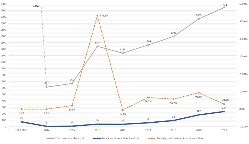
As Fig. 1 shows, only 85 patent applications involving AI were filed for the next 33 years. Since 2016, however, the number of inventions has started to increase sharply. In 2016, there were 38 inventions, marking a staggering growth rate of 533.3%. In 2017, the number of inventions stabilized but then continued to increase. Notably, in 2019 alone, 94 patent applications incorporating AI were filed, surpassing the total number filed during the initial 33-year period. The growth rate between 2018 and 2020 ranged from 66.7% to 93.6% per year. In 2021, the growth rate slowed down to 28.6%.
The overall number of inventions in the field of geological surveys, both with and without AI, grew from 1980 to 2021 (see the gray line in Fig. 1), which indicates growth in the total investment in inventions for geological surveys.
The dynamic growth of inventions incorporating AI suggests that, in the second half of the 2010s, developers increasingly understood the value of AI as a tool in geological surveys and began systematically extracting this value. The growth rate of inventions incorporating AI in geological surveying may stabilize in the coming years. Furthermore, the activity levels in developing geological surveying technologies with AI vary significantly across different categories.
Distribution of Inventions Incorporating AI by Categories
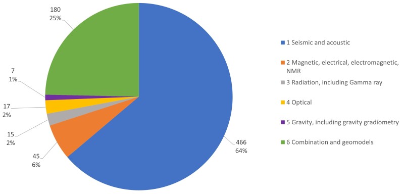
Fig. 2—Distribution of accumulated geological survey methods patents with AI, 1980–2021.
Fig. 2 is a pie chart illustrating the distribution of inventions incorporating AI across different categories. Category 1, “Seismic and Acoustic,” constitutes the majority of inventions, representing 64% of the total inventions. This concentration might be attributed to the following factors:
Widespread use of seismic methods
Very well established data collection technologies
Convenience in data processing because of the low frequency of data flow
Category 6, “Combination and Geomodels,” accounts for the second-largest share of inventions, at a quarter of all inventions. The significant number of inventions in this category can be attributed to the fact that, traditionally, highly experienced geologists were the only ones able to combine different data and create geomodels. But modern AI tools are speeding up, simplifying, and improving the accuracy of the processes in this category. The remaining categories collectively account for only 11% of inventions, with Category 2, “Magnetic, Electrical, Electromagnetic, NMR,” representing 6% of the total. Although these methods collect less data compared to seismic methods, the distribution across categories may evolve in the future. Examining the dynamic diagrams for each category provides further insight.
Dynamics by Years and Categories
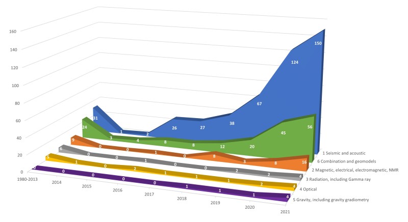
Fig. 3—Geological survey methods inventions with AI by years and categories.
Fig. 3 shows the growth in patent activity in all covered categories from 2020 to 2021. Notably, Category 1, “Seismic and Acoustic,” experienced the highest surge, with an increase of 57 inventions in 2020 and 26 inventions in 2021. This substantial growth has contributed to the current dominance of inventions in Category 1 compared with other categories, as shown in the previous diagrams.
To make assumptions about future invention activity, however, it is crucial to consider not only the absolute growth but also the growth rate in recent years, as depicted in Fig. 4.
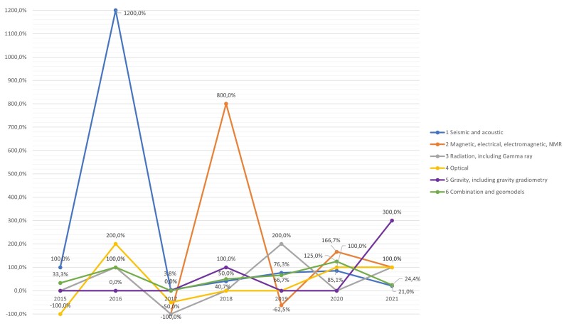
Fig. 4—Growth rate of patents with AI by years and categories.
Fig. 4 shows that, in 2020, Category 1, despite having the majority of accumulated inventions, ranked fourth in terms of growth rate. By 2021, it dropped to the last position, with a growth rate of only 21%. Similarly, Category 6, “Combination and Geomodels,” which ranks second in accumulated inventions, experienced a decline in growth rate and ranked second-to-last in 2021.
In contrast, Category 5, “Gravity,” with the fewest accumulated inventions, exhibited a remarkable 300% growth rate in 2021. Furthermore, Category 2, “Magnetic, Electrical, Electromagnetic, NMR”; Category 3, “Radiation”; and Category 4, “Optical,” all had a growth rate of 100% in 2021.
The observed trend in Categories 2–5 could be attributed to the influence of the low base effect. It is highly likely, however, that, in the upcoming years, the significant growth rate in these categories might lead to a more even distribution of inventions incorporating AI across the different categories.
One of the factors contributing to the growth rate and the number of inventions incorporating AI in each category is the share of the budget allocated to developing technologies with AI within the total research and development budget. The share can be evaluated by calculating the proportion of inventions with AI among the total inventions in a specific category.
Share of Inventions Incorporating AI in Each Category The data presented in the General Statistics section reveals that the share of accumulated inventions incorporating AI is currently only 4.51%. This figure is distorted, however, because of historical data reflecting a minimal use of AI in the early years.
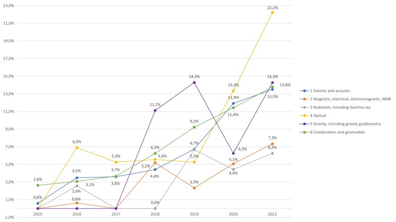
Fig. 5—Proportion of geological survey methods inventions with AI within the total amount of inventions, by years.
Fig. 5 illustrates the growing trend in the share of inventions incorporating AI across all categories. In 2016, this share ranged from 0% to 6.9%. By 2021, it increased to between 6.3% and 22.2%. Notably, in the categories with the highest patent activity, namely Category 1, “Seismic and Acoustic,” and Category 6, “Combination and Geomodels,” the share of inventions incorporating AI reached approximately 14%. This indicates that technology developers are allocating an increasing portion of their development portfolio to AI-powered tools.
The trends suggest a potential increase in the number of inventions incorporating AI in the field of geological surveying in the coming years. This growth could be attributed to two factors:
An increase in total investment in inventions for geological surveying, as indicated in the General Statistics section
The growing share of the budget allocated to developing technologies with AI
The analysis of distribution, dynamics, and share of inventions incorporating AI suggests some overarching conclusions. General Conclusions for Users and Technology Developers The conclusions relevant to users and developers will vary depending on their specific needs, market position, and resources. Some general conclusions can be made, however.
Because Category 1, “Seismic and Acoustic,” and Category 6, “Combination and Geomodels,” have accumulated the greatest number of inventions, users can expect that new products in these categories will incorporate artificial intelligence tools. Products within these categories that do not use AI might seem obsolete. While products that do not use AI in other categories may continue to maintain their market position for a certain period, it is anticipated that the majority of products for geological surveying eventually will incorporate AI tools for data analysis.
Developers focusing on products for seismic and acoustic surveying or geomodelling should use AI tools to be competitive. They may also face challenges, however, because of intense competition and the risk of patent infringement, given the hundreds of valid patents in this category. Besides spending resources on technological challenges, they could be forced to spend additional resources to overcome legal issues. In contrast, it is likely that developers of products in the other four categories have not encountered these difficulties thus far.
The landscape of AI adoption in geological survey technologies is continuously evolving. Monitoring trends in this area using various research methods, including patent research, can provide valuable insights for decision-making in product development and use.
Future patent research in oil and gas exploration can be focused on retrieving information about the implementation of AI in specific areas of geological survey methods. Alternatively, it can explore the use of other modern tools, such as quantum computing, which have already been patented in this field.